
 Latest images
Registry of National Maps
Page 2 of 2 •  1, 2
1, 2
Re: Registry of National Maps
![]() Great Eurussia Tue Nov 19, 2013 3:43 pm
Great Eurussia Tue Nov 19, 2013 3:43 pm
I think the COURT ORDER covers RP Interactions only. As I understand it.Marquette (of Pacific) wrote:Oh, that's right. Shouldn't Eurussia as admin of these forums ban Farshonia?Europe and Asia wrote:He's not allowed on the forums.Marquette (of Pacific) wrote:Why?Europe and Asia wrote:IGNOREEmpire of Farshonia wrote:https://i.imgur.com/fGHouTm.png
It doesn't even say that Farshonia is temporarily banned on the Forums.

Great Eurussia- Superpower
- Posts : 5336
Join date : 2013-02-04 -

Re: Registry of National Maps
![]() Farshonian Empire Tue Nov 19, 2013 4:44 pm
Farshonian Empire Tue Nov 19, 2013 4:44 pm
This is NOT a RP , this is a map registry.

Farshonian Empire- Powerbroker
- Posts : 245
Join date : 2013-05-18
Age : 24
Location : Unknown -
Re: Registry of National Maps
![]() Great Eurussia Tue Nov 19, 2013 4:49 pm
Great Eurussia Tue Nov 19, 2013 4:49 pm
Correct.Empire of Farshonia wrote:Result: Farshonia is hereby banned from Roleplay and the general elections for five weeks.
This is NOT a RP , this is a map registry.
Great Eurussia- Superpower
- Posts : 5336
Join date : 2013-02-04 -
Re: Registry of National Maps
![]() Texania Tue Jan 21, 2014 12:22 pm
Texania Tue Jan 21, 2014 12:22 pm

Texania- Potential World Power
- Posts : 641
Join date : 2013-07-25
Re: Registry of National Maps
![]() Farshonian Empire Tue Jan 21, 2014 5:57 pm
Farshonian Empire Tue Jan 21, 2014 5:57 pm
Farshonian Empire- Powerbroker
- Posts : 245
Join date : 2013-05-18
Age : 24
Location : Unknown -
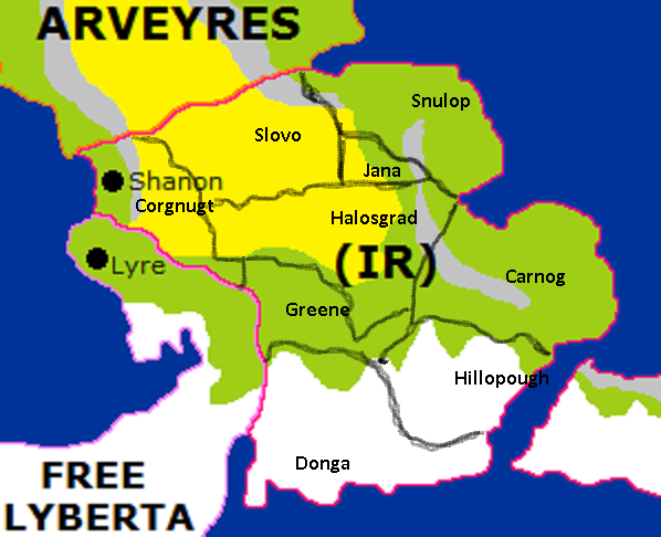
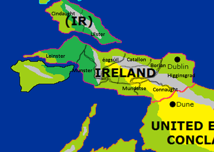

Ireland- Recognized Power
- Posts : 1327
Join date : 2013-12-01
Age : 24
Location : Macon, Georgia, USA -
Administrative Divisions of the Republic of China
![]() Great-Eurussia Sat Mar 01, 2014 3:14 pm
Great-Eurussia Sat Mar 01, 2014 3:14 pm

1. Hong Kong Prefecture
2. Macau Prefecture
3. Hsinchu County
4. Taoyuan County
5. Hualien County
6. Taitung County
7. Kaohsiung County
8. Miaoli County
9. Chiayi County
10. Yilan County
11. Taipei Municipality
Great-Eurussia- Vassal State
- Posts : 14
Join date : 2014-02-25
Location : Great Eurussia -
The Map of Imperial Tokugawan Sphere
![]() Imperial Tokugawa Tue Mar 04, 2014 3:41 pm
Imperial Tokugawa Tue Mar 04, 2014 3:41 pm
Last edited by Imperial Tokugawa on Tue Mar 18, 2014 10:04 pm; edited 4 times in total

Imperial Tokugawa- Powerbroker
- Posts : 124
Join date : 2014-03-04
Age : 30
Re: Registry of National Maps
![]() Great-Eurussia Wed Mar 05, 2014 1:41 pm
Great-Eurussia Wed Mar 05, 2014 1:41 pm
 Tokugawa, your map is virtually a copy of the Inner Mongolia Autonomous Region of China!
That's irredentist and not original at all, and immoral in the highest degree....didn't you profess to be a 'freedom lover' and an 'ardent anti-imperialist'? Besides, this thread is for nations to state their administrative regions with respects to their place on the World Alliance Regional Map, not some warped spun off maps of Northern China in real life.
Great-Eurussia- Vassal State
- Posts : 14
Join date : 2014-02-25
Location : Great Eurussia -
Re: Registry of National Maps
![]() Great Eurussia Wed Mar 05, 2014 4:19 pm
Great Eurussia Wed Mar 05, 2014 4:19 pm
imperial_tokugawa wrote:
Head of State : Haruka Konose
Capital : Fujinomiya City
Substates 8 Substates
1. Ichi
2. Nii
3. San
4 .Yon
5. Go
Special Administrative Teritorries :
1. Volgograd
2. Sekigahara
3. Daoyo
4. Exiled Ienara
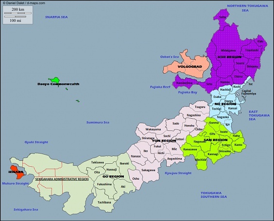
WA Map is the sole source of maps in the region.
Thank you.
Great Eurussia- Superpower
- Posts : 5336
Join date : 2013-02-04 -
Re: Registry of National Maps
![]() Aloia Tue Mar 18, 2014 8:40 am
Aloia Tue Mar 18, 2014 8:40 am
AK-Arikaree
AL-Alberta
AR-Arkania
AX-Alexandria
CD-Costa Dorada
CH-Cheyenne
CM-Cimarron
CO-Columbia
CR-Cote-d'Or
DS-Del Sol
EL-Electra
EM-East Madra
KE-Kendalia
HE-Heliantha
HI-Hiawatha
KA-Kankakee
LI-Lisbon
LT-Lower Talos
MD-Madra
MN-Minnetonka
ND-Nordahlia
NG-New Germaine
NS-New Sokolia
NV-Nievre
OK-Oakland
PA-Pawnee
RD-Rodina
RF-Refugio
RU-Rupinda
SB-San Buenaventura
SF-San Francisco
SH-Shambhala
TE-Talos Eri
UT-Upper Talos
WA-Waubonsee
VI-Victoria
YO-Yonne
ZM-Zumbro

Aloia- Potential World Power
- Posts : 536
Join date : 2013-02-22
Location : Kansas, USA -
Re: Registry of National Maps
![]() Imperial Tokugawa Tue Mar 18, 2014 10:18 pm
Imperial Tokugawa Tue Mar 18, 2014 10:18 pm

Divided into 20 Prefecture's including the Capital Teritorry of the Imperial Tokugawa. except the Exile of Ienara which is battling for it's Independence from the Union. Sekigahara Administrative Region the Substate in the Country which have a Seperate Government and Military Force's but still under the Imperial Tokugawan Monarch Rule. It's Premier was appointed by the Shogun.
Imperial Tokugawa- Powerbroker
- Posts : 124
Join date : 2014-03-04
Age : 30
Re: Registry of National Maps
![]() Kansas Free State Mon Mar 31, 2014 6:35 am
Kansas Free State Mon Mar 31, 2014 6:35 am

Kansas is split into 50 counties, each with its own county seat. Topeka is both the county seat of Shawnee County and the state capital. Kansans also have alternate names for the seas surrounding their nation. The eastern sea is referred to as the Osage Sea and the western sea is referred to as the Kaw Sea. Both seas are named for tribes indigenous to Kansas. Leavenworth is separated from Eurussia's colony by the Strait of Leavenworth and the Sunflower Bay is found on the southwest coast of Kansas. The Kansas river empties into the Sunflower Bay at Kansas City. The bay that separates rivals Dodge City and Garden City is named the Cimarron Bay, for the small island, Cimarron Island, found in the center of it.
- Legend:
- BT - Barton County
- county seat: Great Bend
BU - Butler County
- county seat: El Dorado
CK - Cherokee County
- county seat: Columbus
CN - Cheyenne County
- county seat: Saint Francis
CD - Cloud County
- county seat: Concordia
CR - Crawford County
- county seat: Girard
DC - Decatur County
- county seat: Oberlin
DG - Douglas County
- county seat: Lawrence
EL - Ellis County
- county seat: Hays
EW - Ellsworth County
- county seat: Ellsworth
FI - Finney County
- county seat: Garden City
FO - Ford County
- county seat: Dodge City
GO - Gove County
- county seat: Gove City
GH - Graham County
- county seat: Hill City
GT - Grant County
- county seat: Ulysses
HM - Hamilton County
- county seat: Syracuse
HV - Harvey County
- county seat: Newton
JA - Jackson County
- county seat: Holton
JO - Johnson County
- county seat: Olathe
KE - Kearny County
- county seat: Lakin
KW - Kiowa County
- county seat: Greensburg
LB - Labette County
- county seat: Oswego
LV - Leavenworth County
- county seat: Leavenworth
LC - Lincoln County
- county seat: Lincoln Center
LG - Logan County
- county seat: Oakley
MC - Mitchell County
- county seat: Beloit
NM - Nemaha County
- county seat: Seneca
NO - Neosho County
- county seat: Erie
NT - Norton County
- county seat: Norton
OB - Osborne County
- county seat: Osborne
PL - Phillips County
- county seat: Phillipsburg
PT - Pottawatomie County
- county seat: Westmoreland
RA - Rawlins County
- county seat: Atwood
RL - Riley County
- county seat: Manhattan
RO - Rooks County
- county seat: Stockton
RH - Rush County
- county seat: La Crosse
RS - Russell County
- county seat: Russell
SG - Sedgwick County
- county seat: Wichita
SN - Shawnee County
- county seat: Topeka
SD - Sheridan County
- county seat: Hoxie
SH - Sherman County
- county seat: Goodland
SM - Smith County
- county seat: Smith Center
SV - Stevens County
- county seat: Hugoton
SU - Sumner County
- county seat: Wellington
TH - Thomas County
- county seat: Colby
TR - Trego County
- county seat: WaKeeney
WA - Wallace County
- county seat: Sharon Springs
WH - Wichita County
- county seat: Leoti
WL - Wilson County
- county seat: Fredonia
WY - Wyandotte County
- county seat: Kansas City

Kansas Free State- Sovereign State
- Posts : 6
Join date : 2014-03-30
Re: Registry of National Maps
![]() Latvya Wed Apr 09, 2014 6:20 am
Latvya Wed Apr 09, 2014 6:20 am

1 - Kurzeme
Regional population: 224,931
Capital: Baloži
Capital population: 91,293
2 - Zemgale
Regional population: 183,784
Capital: Valdemarpils
Capital population: 53,184
3 - Vidzeme
Regional population: 1,783,477
Capital: Daugavpils
Capital population: 992,496
4 - Lubskỳu
Regional population: 662,859
Capital: Jurmalǎ
Capital population: 239,147
5 - Latgale
Regional population: 73,582
Capital: Aænažu
Capital population: 22,193

Latvya- Sovereign State
- Posts : 3
Join date : 2014-04-09
Re: Registry of National Maps
![]() De Vrije Gebieden Sat Apr 19, 2014 11:37 am
De Vrije Gebieden Sat Apr 19, 2014 11:37 am
Here is a link of the land we would like to claim. Our capital is amsterdam and yes the two islands are ours too. (If it pleases to administration)
De Vrije Gebieden- Sovereign State
- Posts : 1
Join date : 2014-04-17
Re: Registry of National Maps
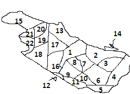
![]() New Tarajan Mon Apr 21, 2014 9:05 am
New Tarajan Mon Apr 21, 2014 9:05 am

1. Shahdom of Astana (Tarajan)
12. Principality of Merlberg
2. Grand Duchy of Muraz
22. Grand Duchy of Alleskandberg
13. Grand Duchy of Bakran
11. Landgraviate of Nuyern
18. Landgraviate of Aaken
3. Principality of Horat: House Rumaki
17. Duchy of Koenigscasteel: House Van Der Grudeln
15. Duchy of Eindhoven: House Van Geldern
19. County of Marisah: House Shatrevar
14. County of Heinrichstadt: House Van Aardenne
16. Landgraviate of Bergenfort: House Van De Meester
20. Landgraviate of Meisjecasteel: House Jorahan
21. Barony of Shraman: House Taher
4. County of Vaandal: House Van Peeuw
5. Duchy of North Brandelhorn: House Van Leeuwen
7. Duchy of South Brandelhorn: House Van De Groot
6. Principality of Groteweg: House Van Sondenburg
8. Duchy of Hogeberg: House Amasya
9: Principality of Benham: House Rumi
10: County of Wittenberg: House De Witt
Grand Duchy of Markenstadt (Principality of Merlberg): House Acribaldi-Romanov-Astril, Arveyres
Duchy of Erjentold (Shahdom of Astana): House of Aloia

New Tarajan- Recognized Power
- Posts : 1340
Join date : 2013-06-23
Location : Rome, Italy
Re: Registry of National Maps
![]() Kansas Free State Mon Apr 21, 2014 10:35 am
Kansas Free State Mon Apr 21, 2014 10:35 am

A map of major Kansan cities and their urban areas. Yellow regions are urban areas.
Kansas Free State- Sovereign State
- Posts : 6
Join date : 2014-03-30
Re: Registry of National Maps
![]() Maastrijk Wed Apr 30, 2014 6:47 am
Maastrijk Wed Apr 30, 2014 6:47 am

Kapitaal-
Capital: Geertruidenberg
Population: 2,950,280
Noorden Eems-
Capital: Leeuwarden
Population: 1,232,951
Zuiden Eems-
Capital: Middelburg
Population: 745,819
Gelderland-
Capital: Westkapelle
Population: 1,086,331

Maastrijk- Vassal State
- Posts : 12
Join date : 2014-02-02
Re: Registry of National Maps
![]() Dromoda Sat May 03, 2014 2:08 am
Dromoda Sat May 03, 2014 2:08 am
Maastrijk wrote:
Kapitaal-
Capital: Geertruidenberg
Population: 2,950,280
Noorden Eems-
Capital: Leeuwarden
Population: 1,232,951
Zuiden Eems-
Capital: Middelburg
Population: 745,819
Gelderland-
Capital: Westkapelle
Population: 1,086,331
i'm sorry but Capital in dutch is Hoofdstad

Dromoda- Potential World Power
- Posts : 783
Join date : 2013-02-06
Age : 29
Location : Kyongdong,Chengdao, Dromoda
Re: Registry of National Maps
![]() England and Wales Thu Nov 06, 2014 3:42 pm
England and Wales Thu Nov 06, 2014 3:42 pm
Wards 1, (The Capital ward)
Capital: Atlantica
Ward 2
Capital:Trent
Ward 3
Capital: Clocktown
Ward 4
Capital: Kohan
Ward 5 (once the capital region of the republic of Blitzen)
Capital: Blitzen
Ward 6
Capital: Flekendorf
Ward 7 (military controlled)
Capital: Fire base Stag
Ward 8
Capital: Mackenrodt
Ward 9
Capital: Stonehall
Ward 10
Capital: New Marsh
Ward 11
Capital: Greemelf
Ward 12
Capital: North Rosemeadow (South rosemeadow was destroyed)
Ward 13 (Controlled by the Navy but houses civilians, is also the Trade Capital of Atlantica)
Capital: Docktown
Ward 14
Capital: Westerby
Ward 15 (Order of Atlantican Knights)
Capital: Old Atlantica
Ward 16 (Controlled by Air force, houses civilians)
Capital: Fieldmill
Ward 17 (Under quarantine, details are unknown)
Capital: Under quaratine
Ward 18
Capital: Strongmere
Ward 19
Capital: Crystaliron
Ward 20 (war zone)
Capital: South Rivercliff (North under rebel control)
Ward 21
Capital: Kingcole
Ward 22 (Restricted to state officials and the military only)
Capital: Restricted

England and Wales- Powerbroker
- Posts : 287
Join date : 2014-11-02
Re: Registry of National Maps
![]() Apepistan Thu Dec 11, 2014 10:23 pm
Apepistan Thu Dec 11, 2014 10:23 pm

Old Kingdom (Founded 470 AD):
1. Apepistan
Founding of the United Kingdoms (474-499 AD):
2. Turkistan (joined)
3. Kingdom of Sarkel (conquered)
4. Tataria (conquered)
5. Kingdom of Onogur (joined)
Further expansions (grouped into "waves" of expansion)
500-896 AD
6. Tohotom (joined)
7. Orkhon (conquered)
8. Bataaria (conquered)
9. Ulania (conquered)
10. Kirgizstan (conquered)
900-1502 AD
11. Kazaria (conquered)
12. Atilstan (joined)
13. Madjarstan (conquered)
14. Kingdom of Levedi (conquered)
1503-1867 AD
15. Kingdom of Etelia (conquered)
16. Kingdom of Skithia (joined)
17. Keletistan (joined)
1868 AD-Present
18. Kipchakistan (joined)
19. Republic of Pontia (conquered)
The official title of every territory is "kingdom", though they are often referred to as "tribes".
All kingdoms have the same level of authonomy within the United Kingdoms. The kingdoms, however, have no separate kings, the king of every kingdom is the Ahet-Apep (currently Ahet-Apep LII, Tarjan Kerkesi)

Apepistan- Regional Power
- Posts : 439
Join date : 2014-09-27
Location : Budapest, Hungary
Re: Registry of National Maps
![]() Trinity Sector Thu Mar 12, 2015 2:08 pm
Trinity Sector Thu Mar 12, 2015 2:08 pm

Order of importance:
18: Statue of Slave made of Bronze, Breaking his Own Chains. on the bottom of the foundation reads: Religio, dominos, pax bellum, non argentum, non patriae solum intelligunt. (No religion, No masters, No peace, No war, No money, no country, Only understand.) it is a national Park monitored under 13. 18 is called The Door-Mat
14: belongs to the Atomic Dogs. called Man's Best island
1: The First kingdom: national capital; Area 2020
2: Farmer's Sector. Island capital: area 1456
3: native Sectarians' Domain. island capital: Rain-unearth-Fire
4:Neutral Sector. island capital: unknown name
5: Prison of peace island capital:
6: Val'Kera island capital: Area 0000
7:First lord Logan's Kingdom. island capital: 1001
8:First duchess Jennifer's kingdom. island capital: 7389
9:Queen's island. island capital:2344
10: Selfie island. Island capital: Click
.11: Euntes in: island capital: area 0047
12: Navy Outpost
13:Navy Outpost
15: Egressus. island capital: Area 0025
16: extension of 2
17: exstension of 8

Trinity Sector- Powerbroker
- Posts : 211
Join date : 2015-03-03
Age : 28
Location : New York, USA -
Re: Registry of National Maps
![]() Ebsotz Mon Mar 30, 2015 11:08 am
Ebsotz Mon Mar 30, 2015 11:08 am
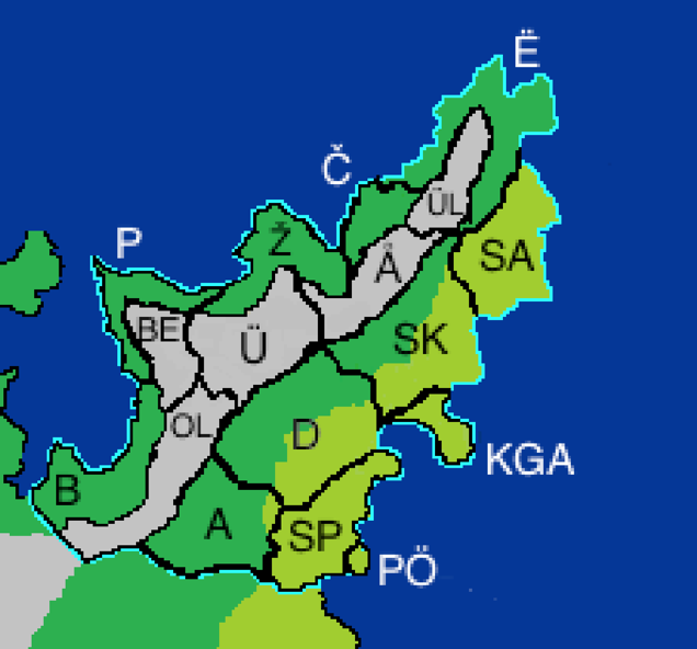
(Č= Čulžom. Province Seat= Čulžom) (Ё= Ёvangelheim. Province Seat= Kründheim) (ÜL= Ülokio. Province Seat= Fjöllia) (SA= Slavaheim. Province Seat= Dalmacija) (Å= Ålond Histortic District. No Province Seat) (SK= Slokoland. Province Seat= Sülm) (KGA= Križanić Government Area. Province Seat= Križanić) (D= Domvernika. Province Seat= Plovograd) (PÖ= Port Öctozimur. No Province Seat) (SP= South Plavigrad. Province Seat= Plavigrad) (A= Asgeschutz. Province Seat= Asgeschutz) (OL= Olmz. Province Seat= Olmz) (B= Brizać. Province Seat= Brizać) (Ü= Üslokia. Province Seat= Üslo) (Ž= Zerä. Province Seat= New Čulžöm) (NE= New Eisenbürg. Province Seat= Eisenstadt) (P= Podgörika Province. Province Seat= Podgörika)

Ebsotz- Powerbroker
- Posts : 297
Join date : 2014-10-07
Location : Southern California -
The Regions, Roads, and States of the USSR - March 30, 2015
![]() The Sanchez Republic Mon Mar 30, 2015 10:42 pm
The Sanchez Republic Mon Mar 30, 2015 10:42 pm

THE REGIONS OF THE USSR, AND THEIR CAPITALS:
0 – Kingston D.C. (District of Columbia) *Capital*
1 – Maryland - Edwardsville
2 – Abolonia - Vicksburg
3 – Regina - Pauland
4 –Montana - New Highland
5 –Midlands - Roosevelt
6 – Florida - Santa Cubillos-Havana
7 – Illinois - Agnes

ROADS OF THE USSR...

The Two States of the USSR:
1 - The Sanchez State: Leader in all things non manufacturing (i.e. Book publishing, farming, and home of the gambling industry in Santo Cubillos-Havana, Florida, and home of the economic center of the USSR in Pauland, Regina).
2 - The Grabowski State: Leader of the manufacturing of the USSR (i.e. Automobile industry, soda production, steel milling, powerhouse of the country with it's energy plants in New Highland, Montana, and it's fishing industry in Agnes, Illinois).

The Sanchez Republic- Vassal State
- Posts : 19
Join date : 2015-03-27
Age : 29
Location : The United States of the Sanchez Republic
Re: Registry of National Maps
![]() West Phoenicia Thu Apr 02, 2015 8:08 pm
West Phoenicia Thu Apr 02, 2015 8:08 pm

West Phoenicia is a wealthy country; it generates its income from various sources including;
*The city state of Upper West Phoenicia is the nations leading producers of gold and sapphires mining accounting for 49% of all mining related exports.
*Lower West Phoenicia has a booming cotton and hops industry with large cotton plantations. The hops are used to make "Nectar of the gods' a West Phoenician beer which is sold and imported.
*Immaculata with its rich fertile flatlands has an abundance of tobacco plantations which export 70% of their produce.
*Agape is a leading exporter of wine, cheeses and religious icons and home to the Headquarters and palatial grounds of the State Church.
* Bast County is oil territory.. With oil being discovered. Production has been under way to supply the nation and export large amounts. Currently as a nation we are producing 700, 000 bbl/d
*New Tudor is the leading exporter of tea and coffee which is grown abduantly in the farm lands of the northern part of New Tudor. The southern part of the city state is the home of the automobile manufacturer industry.
*Jackson, the seat of the nation's capital is home to the government, The First National West Phoenicia bank and telecommunications industries. All major television and radio broadcasting both in West Phoenicia and to the world is located throughout. It also houses The West Phoenician Supreme Court and The High Court of West Phoenicia.
* Olympia Hills is the home to the West Phoenician entertainment industry consisting of a thriving movie and music industry. As well as the residence of the aristocracy class.
*The city-state of Brigham Territory is the largest beef producing city state. With vast ranches and cattle stations.
*Deception Bay is home to a booming steel industry and holds the current West Phoenician Navy military contracts building and constructing of their fleets.
*Ptolemaic Haven is a city state of philosophy and education. Flourishing with universities, opera houses, libraries and art galleries. Its one of the cultural hubs of the Kingdom of West Phoenicia. Boasting the Great Ptolemaic Haven Library a collosial architectural wonderment housing millions of books and a replica of the Great Library of Alexandria in Egypt
*Bast County, Baal Territory, Selene Valley and Helios Region are the 4 pagan strongholds in the kingdom. With 80% of the population professing to be pagan it holds temples to a multitude of gods and goddess and animal deities. Large open markets. Growers of organic fruits and vegetables. And home to legalised temple prostitution. These four regions also have thousands of shops and stalls dedicated to witchcraft, palm readijg, mediums, tarot reading, astrology, magic charms and potions etc.
*St Mary's is the city state dedicated to the fishing industry.
*Antebellum Territory is another wealthy region a great tourist destination for retreats, spas and relaxatiin centres. It is also the hub of artisans manufacturing jewellery, pottery and fine china and silks and the fashion industry.
* Tallahassee Central is the sporting state of the Kingdom. Home to the famous West Phoenician Horse racing cup, motor racing, bull fighting and gladiator sports.
* New Dixie houses the West Phoenician Military Headquarters and West Phoenician Intelligence Agencies.

West Phoenicia- Emerging Powerbroker
- Posts : 51
Join date : 2015-03-30
Age : 45
Location : Australia
Page 2 of 2 • 1, 2
» Registry of National Currency
» Registry of National Emblems
» Registry of National History
» Registry of National Anthems